|

A Brief History of Delta Ontario
| |
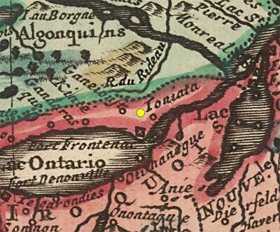 |
| | Tribal BoundariesThis early 1700s map shows Algonquin territory in green and Iroquois (Haudenosaunee) in red, the boundary in the Rideau Corridor at that time (early 1700s) just south of the watershed divide at Newboro. The yellow dot is the approximate location of Delta. Toniata (open circle below the name) is present day Brockville and Fort Frontenac is present day Kingston. Today, Delta is part of an Agreement in Principle Land Claim with the Algonguins of Ontario.
From: Canada ou Nouvelle France Suivant les Nouvelles Observations by Pieter van der Aa, 1713 (based on an earlier 1703 map by Guillaume De L'Isle)
|
The human history of the region dates back to the last ice age. Some 18,000 years ago the ice age peaked and Delta was under almost 2 kilometers (1.2 miles) of ice with the overall landscape depressed by 175 m (575 feet). There were no humans at this time, we (humans) started to appear about 10,000 years ago as the land became exposed with the retreat of the glaciers. It was a sub-arctic climate at that time and the main game animal was caribou. The land was rising with weight of the ice lifted off it and by about 8,000 years ago the topography and vegetation seen today developed. Over time, large mammal life transitioned from caribou to moose to white tailed deer. Fish was abundant in the lakes, including Lower Beverley Lake (originally known as White Fish Lake).
Lower Beverley Lake is part of a very long time indigenous water travel route, locally there is evidence of hunting and fishing camps used by the Point Peninsula peoples over 2,000 years ago. But use of this water route likely extends back at least 9,000 years supported by archaeological evidence on Lower Rideau Lake where a slate tool with a carving of people in a dugout canoe was found, dating back to approximately that time.
While there were no permanent indigenous settlements, the Delta area saw overlapping use by various indigenous groups including the Wendake-Nionwentsïo, the Haudenosaunee (Iroquois Confederacy), Missisauga, Anihinabewaki and Algonquin. Many of these groups were in conflict with each other, with one group displacing another over time. Today, Delta sits on the southern boundary of an Agreement in Principle Land Claim with the Algonquin of Ontario.
| |
 |
| |
The local geography, particularly the watersheds and water flow are confusing. Delta is part of the Gananoque watershed which, prior to the building of mill dams and later the Rideau Canal, included the southern Rideau lakes. In 1783, the first European survey of the route was done by Lt. Gershom French. He had an indigenous guide and they followed the long time travel route from the Ottawa River, up the Rideau River and then down through the Rideau lakes to Jones Falls. At that time, the White Fish River flowed from Jones Falls to Lower Beverley Lake (Morton Creek is a flooded remnant of that river), with the route ending in Gananoque.
|
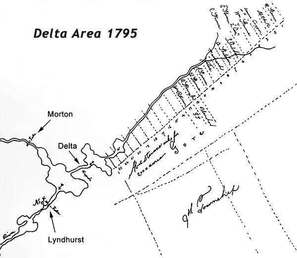
The settlement of Delta as a permanent village started with Abel Stevens, a loyalist from Vermont who arrived in this area in February 1794 with several families and squatted on upper reaches of Plum Hollow Creek (see map below). The area was unsurveyed and Stevens petitioned to be granted land around both the rapids at Delta and the "Great Falls" at Lyndhurst, applying to set up an iron foundry in that location (Lyndhurst). The first survey lines were run into the area by William Fortune in July 1794 and then in 1795, surveyor Lewis Grant ran the initial survey of what was to become Bastard Township. In 1796 sufficient surveying had been done to grant Stevens 5 lots in Bastard Township (on June 2, 1796 - 700 acres total) including 3 over what is today's Delta (Lots 23, 24 & 25 in the 9th Concession of Bastard Township).
| |
 |
| |
Delta is located on an eastern margin of the Frontenac Axis, the eroded remnants of a very old (900 million years) mountain range formed by continental collision. Adjacent to that are younger (a mere 500 million years) flat lying sedimentary rocks (sandstone) which overlie the older metamorphic rocks. The topography of the Frontenac Axis forms rapids in places, water power that early pioneers developed. But it was poor farmland (the soil unit on top of these rocks is known as "rockland"). But there is fertile soil overlying the flat lying sandstone rocks and this is where Able Stevens led the first group of settlers, to the upper reaches of Plum Hollow Creek. You can see on this map that Stevens at this time is petitioning for 2,000 acres of land. He was also petitioning for the water rights for the rapids at Delta and the falls at Lyndhurst. In the end, in June 1796, he was given 700 acres of land, encompassing much of today's Village of Delta.
|
In about 1796, Abel Stevens had a wooden sawmill built, that mill is recorded in Lewis Grant's 1797 field notes as "Wm. Stevens Mill" - William was Abel's cousin. It was built after Stevens received his land grant on June 2, 1796. A wooden grist mill was added later. The first confirmed reference to that is 1803 when it was leased to Nicholas Mattice (refrences to Mattice go back to 1799, so it could have built closer to that date). The exact location of the first sawmill uncertain, it is shown as being on the south side of the creek on Grant's 1797 survey map of Bastard Township. That location is believed to be somewhere near the intersection of today's Mathew Street and King Street since Recreation Street and the Drive Shed for the Old Stone Mill are located over the original creek bed. Anecdotal history (memoirs of Hiel Sliter) indicate that the Stevens' grist mill burned down twice.
| |
 |
| |
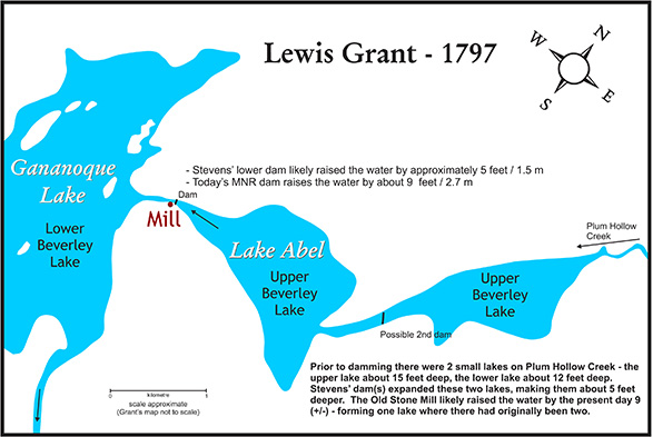
In this cleaned up version of surveyor Lewis Grant's 1797 map we can see that Abel Stevens' sawmill was located on the south side of Plum Hollow Creek which flowed through two small lakes, which were dammed by Stevens to provide a higher head of water for his sawmill. A grist mill was built later, either adjacent to or across the stream from the sawmill. Those sites are now buried under the streets of Delta, today's location would be approximately the intersection of Recreation Drive and King Street.
The Old Stone Mill is NOT built on the site of the original Stevens' mills, it is located about 50 metres north of those mills. The reason is that because it was a large stone structure, it had to be built on bedrock. The Stevens mills were built on sediments (likely hard clay, similar to what underlies the Jubilee Block). The Old Stone Mill is built on the closest bedrock north of the original stream channel. Since the location of the Old Stone Mill was not in the stream channel, an artificial channel had to be blasted through bedrock to the mill. The material from that excavation was used to fill in the original stream channel, burying what would have been left at the time (1810-11) of the original Stevens mills.
|
Early references (Stevens' petitions) to the area are as Stevenstown, as the regional area (township) not a village, but later this name became synonymous with the fledgling village that developed after the first mill was built. Stevens was responsible for local roads that helped to develop Delta, firstly, in 1794, a rough road from Brockville to the upper reaches of Plum Hollow Creek (built for the settlers wagons), then a road to the Delta area, and then, in 1798, he had a road built from the Delta Road to the main road near Kingston Mills. These collectively became known as the "Kingston Back Road."
By 1808 a second sawmill was built in the village by Abel Steven's Jr. on today's Foundry Creek. In June 1808 Abel Stevens Sr. sold his mills and the land they were on to William Jones. In 1809 we see Jones' business partner, Ira Schofield, operating Stevens' old grist mill as well as the sawmill.
In 1810, William Jones started construction on a new mill, a 3 1/2 storey, Georgian architecture style, stone mill, using an automated mill design by American inventor Oliver Evans. The mill was located on bedrock, north of Stevens' original mill. A new water channel was excavated from Upper Beverley Lake to the mill and the original rapids and stream channel in the area of the original Stevens' mills was filled in. Abel Stevens' dam likely raised the water in the original Upper Beverley Lake by about 4 to 5 feet (based on the appearance of the two Upper Beverley lakes on Grant's 1797 survey map of Bastard Township), the new stone mill, which acted in part as its own dam, with an adjacent bywash, raised the water level by about 9 feet (+/-), forming one lake where there had originally been two.
In 1811 construction started on a new Baptist Church, today's St. Paul's Anglican Church. The Baptist group ran out of funds before the church could be completed. It was purchased by the Anglicans in 1827 who completed the construction.


In this photo of the bell, the forging date of 1826 can be seen. DMS Photo Archives (Paul Fritz collection) |
By 1816, the small community, now known as Stone Mills, had between 10 and 20 houses (an 1816 letter indicates about 20 houses in the area and a July 1816 map shows 10 buildings in Delta). In about 1827, the village of Stone Mills was renamed Beverley after Sir John Beverley Robinson (a prominent Upper Canada politician and later Chief Justice of Upper Canada). An anecdotal story is that Sir John, a staunch Anglican supporter, promised to donate a bell to the Anglican Church (just purchased from the Baptists) if they would name the village Beverley - and so the village was renamed and the church got its bell. The name Beverley shows up on an 1828 map where it states "Beverley is composed of abt 30 houses".
| |
 |
| |
A section from Lt. Joshua Jebb's 1816 map of the Rideau Route. Jebb, a young (early 20s) Royal Engineer surveyed road systems in the area in the spring of 1816 and then in June and July did a full survey of the Rideau Route from the Ottawa River at Rideau Falls to Kingston. His map, although inaccurate in several area, is quite remarkable. We can see Delta, then known as Stone Mill, with 10 buildings. White Fish Lake is today's Lower Beverley Lake. Haskins Mill (built by Lemuel and Carey Haskins sometime between 1803 and 1805) is today's Morton and Furnace is Lyndhurst. At this time, with the higher damming of the Upper Beverley Lakes by the Old Stone Mill, it was now a single lake, a water level maintained to this day (now by an MNR dam, built in 1962, just east of the King Street Bridge).
Jebb recommended a shortcut route for the Rideau Canal, known as the Irish Creek Route. It would have passed right through Delta on its way back to the original Rideau Route. The next Rideau Route surveyor, Samuel Clowes, discounted Jebb's recommendation and recommended that the canal be taken through the Rideau Lakes, the route it follows today.
|
In 1828, the temperance movement in Upper Canada got its start in Delta with a 4 hour sermon delivered on June 10, 1828, by Dr. Peter Schofield, an eminent medical doctor, distressed by the impact of drunkenness on society. Dr. Schofield delivered the sermon in the Old Stone Mill, a highlight of which was his rather vivid description of death by ″spontaneous combustion.″ He noted that ″it is well authenticated, that many habitual drinkers of ardent spirits are brought to their end by what is called spontaneous combustion″ and then went on to describe in some detail an event he’d heard about.
| |
 |
| |
On June 10, 1828, Dr. Peter Schofield delivered a four hour sermon on the many evils of drink in the Old Stone Mill. This marked the beginning of the Temperance Movement in Upper Canada. Dr. Schofield was a resident of Delta, his house burned down in 1990. In a bit of irony, the view he would have today from his front porch is the LCBO, which was built directly across the street from his house. From the DMS Photo Archives, Paul Fritz Collection.
|
One of the most prominent residents of Delta was Walter H. Denaut. Born in Prescott, Denaut worked in Delta for a time before returning permanently in 1839, opening up a general store. In 1850 he bought the Old Stone Mill from the previous owner, Amelia Macdonell. He invested heavily in the mill, including switching power from a waterwheel to turbines in the early 1860s. The mill was known at that time as Denaut's Mills. Completed in 1851, his impressive family home is known today as Denaut Mansion.
| |
 |
| |
The building in the middle of this c.1905 photo (colourized postcard), is Denaut Hall, built by Walter Denaut in the 1850s. It featured a brick hall above a stone carriage shed foundation. It was Delta's first community hall, hosting meetings, dances and concerts. It also served as Delta's first court house. The later construction (1879/80) of the Old Town Hall, which served as a municipal office and District Court House, led to the decline in use of Denaut Hall. In the 1920s, then owner of the Old Stone Mill, Hastings Steele sold it to George Snider who repurposed the carriage shed portion into a Blacksmith Shop. In the early 1960s, then owner Gordon Gray had the brick upper storey torn down and replaced with the current wooden framed upper half storey. The Delta Mill Society purchased the building in 1994, using it for oversize artefact storage and as a blacksmith shop, demonstrating that heritage art to the public. The DMS renovated the shop in 2022 and it continues to showcase blacksmithing to the public. Photo of a colourized postcard from the DMS Photo Archives.
|
| |
 |
| |
This c.1910 photo shows Denaut Mansion. The stone side was the living quarters for the family, the brick side for the servants and included the main kitchen facility. A January 1851 account stated "Mr. Denaut has built quite the castle on the rising ground back of the village which when finally finished will be a splendid residence." Photo from the DMS Photo Archives; Paul Fritz Collection; colourized by kww.
|
In 1857 when a new Post Office was applied for, the name Beverley was already taken and the name Delta was chosen because the shape of the two Beverley lakes, connected by the village, resembles triangles - the shape of the fourth letter of the Greek alphabet, delta.
| |
 |
| | Old Stone School - c.1875
One of the earliest stone schools in the area, built c.1850, this location was later (1879/80) used for the building of the Old Town Hall. It is likely that the lower stone foundation of the hall used stones from the demolition of this school. The bell hanging in the air is because this area of the original photo was blown out (all white) except for the bell - it is assumed the bell hung from a metal or wooden frame. Photo from the Rideau Lakes History Centre collection - colourized by kww.
|
| |
 |
| | Old Town Hall - c.1910
Built in 1879/80, the lower floor was used for municipal offices and the district courthouse with the upper floor a masonic hall. Photo from the DMS Photo Archives, colourized by gwr.
|
| |
 |
| | Jasper Russell Brickyard - c.1900
The bricks used in the building of the Old Town Hall came from the Jasper Russell brickyard, located just behind today's post office. Jasper charged 4 cents per 1,000 bricks for the Old Town Hall. Photo from the DMS Photo Archives, Paul Fritz Collection. Colourized by kww.
|
| |
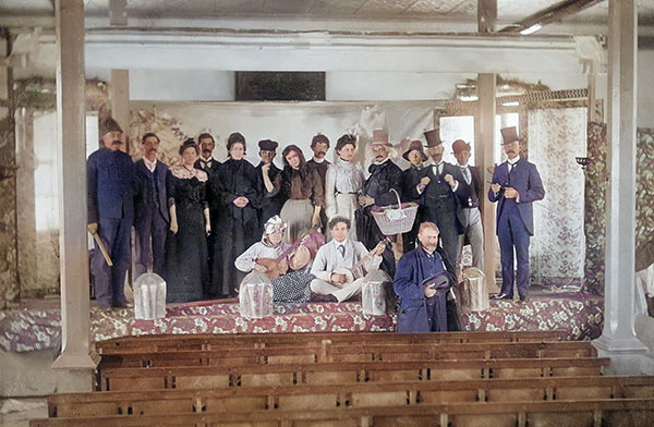 |
| | Actors on Stage - c. early 1900s
Cast of Annual New Years' Day amateur play in the Old Town Hall. Left to right, back row: George Godkin, Bill Percival, Mattie Percival, Isaac Stevens, Brayton Bresee, Ruby Stevens, Sam Waley, Mrs Sam Whaley, William Birch, Tommy Collister, Jerb Suffle, Bill Morris, Ed Barlow.
Front Row (l to r): Margaret Barlow, Dr. Kreegan, Harry Knox (a commercial salesman from Iroquois, Ontario who was commandeered to participate because he could play the banjo).
Photo from the Rideau Lakes History Centre. Colourized by gwr.
|
For years Delta was the only significant community in the region due to the Old Stone Mill with farmers going to the mill to get their wheat ground into flour and/or selling their surplus wheat to the mill. Businesses such as merchant shops, taverns, inns, blacksmiths were established to service this influx of people, Delta was the regional service centre. By 1851 the population of Delta was 250 and an 1897 fire insurance map shows a population of 500.
| |
 |
| |
A section from the 1897 Fire Insurance Map of Delta. It is colour coded by the type of building material used for the ground floor of any building, including blue for stone and pink for brick. The brick Jubilee Block on Main Street (later King Street) is shown as being under construction. An earlier business block, a 3-storey high building, burned down in 1896. The Old Stone Mill and Turbine Hall are shown as is Denault Hall, now the Blacksmith Shop. That building is shown in blue due to the stone foundation (carriage shed portion) for the brick upper storey. The Old Town Hall at that time was a rectangular building, the brick side addition seen today was done in the early 20th century.
|
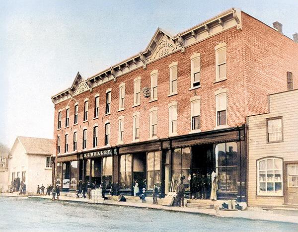
The original Delta Business Block built in 1885-86. It burned down in 1896.
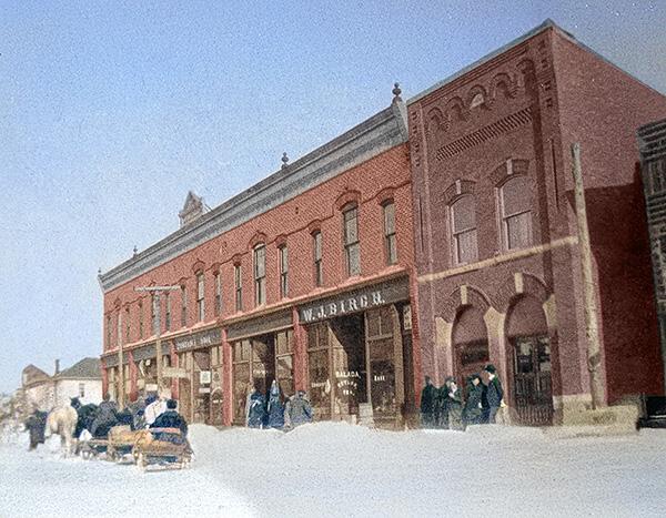
The Jubilee Block built in 1897. Photo c.1900.

Downtown Delta in the 1930s.
Photos from the Delta Mill Society digital photo archive.
Enhancement and colourization by G.W. Russell.
The Brockville, Westport and Sault Ste. Marie Railway started service to Delta in 1888. In 1910 it was bought out by the Canadian Northern Railway who were acquired by CNR in 1923. CNR operated the line through to mid-1952. The village had one of the larger stations on the line. Today, sections of the train bed serve as roads and/or paths used by all terrain vehicles.
| |
 |
| | CNR Train at the Delta Station. nd.
Delta Mill Society Photo Archive, Paul Fritz Collection. Colourized by kww.
|
The village has seen many changes over the years. A significant one was change to the original millpond when the Ontario Ministry of Natural Resources (MNR) took over water control from the Old Stone Mill in 1961. Prior to that time, the millpond which included Upper Beverley Lake, was up against the mill with a stoplog dam at the head of the mill's bywash. That dam controlled the water level of the millpond (Upper Beverley Lake). In 1962, MNR built a new stoplog dam just upstream of the King Street Bridge. That lovely stone bridge was built in the late 1860s or early 1870s. In 1963, it was demolished and replaced with the current concrete bridge.
| |
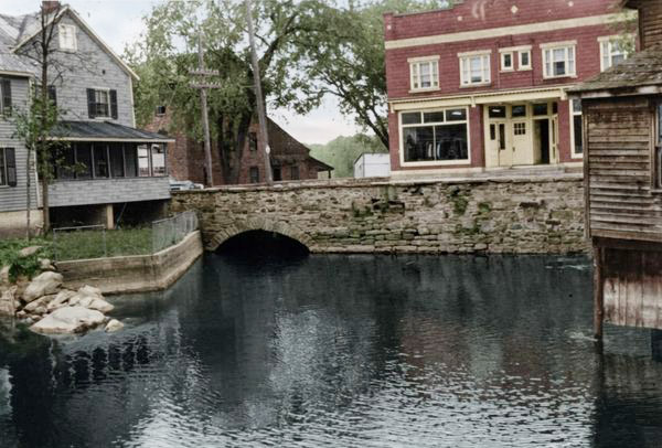 |
| | Old Stone Bridge, early 1960s, Looking East
This lovely stone bridge was built in the late 1860s or early 1970s. It was demolished in 1963. In the background right is the old Russell store which was demolished in 2019. To the left is the Sexton House which burned down in 1983. In the background left is the Old Stone Mill which is still standing.
Delta Mill Society Photo Archive, MNR Collection. Colourized by kww.
|
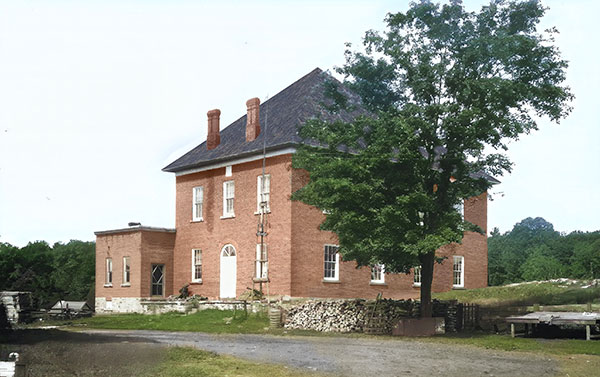
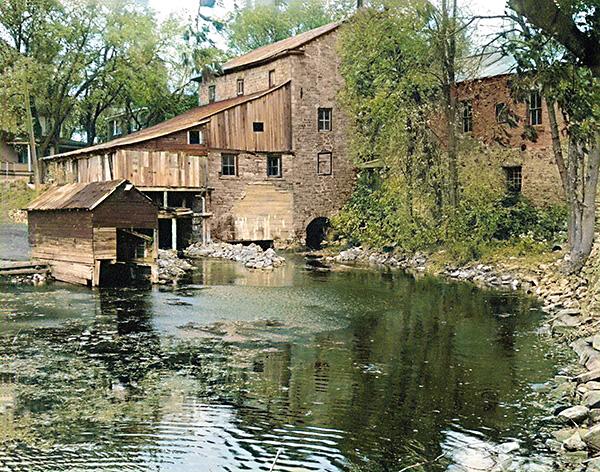
The village's Old Stone Mill saw use for 150 years, from 1810 thru 1960, and played an important role in the area's wheat harvesting needs. In 1963, Hastings Steele, the mill's final owner, deeded the property to a group of trustees for $1. These trustees formed the core of The Delta Mill Society who extensively restored the mill (rescue rehabilitation in 1973-74 and major conservation rehabilitation in 1999-2004) and have it open to the public during the summer and for special events. In 1970 the mill was designated a National Historic Site of Canada.
| |
 |
| |
In this colourized version of a b&w 1957 photo we see the state of the Old Stone Mill just prior to full closure (1960). On the right side is the back of Denaut Hall with the full extent of the stone foundation visible (now mostly covered with backfill). A major crack in the south wall of the mill (evident in early 1900s photos) has been repaired. The Turbine Hall has a large cement patch over the exit of the turbine raceway indicating the failure of the original stone arch. Adjacent to the Turbine Hall is the sawmill which was built above the bywash. A boathouse sits on the mill stream. Photo from the DMS Photo Archives, Paul Fritz Collection. Colourized by gwr.
In 1961, the Ontario Ministry of Natural resources took over water control, operating the stop-log dam at the head of the bywash, which at that time controlled the level of Upper Beverley Lake. By this point the upper part of the sawmill had collapsed, leaving only the floor. In 1962, MNR built a new stop-log dam upstream of the King Street bridge (the dam we see today) and removed the dam at the head of the bywash as well as the remains of the sawmill. They later cemented in the walls of the bywash, which is what can be seen today.
|
Another influential local business was the Confederated Foods syrup bottling plant (aka Maple Syrup Factory), employing many residents for decades and providing an extra attraction to the village's annual maple syrup festival. Its last owner neglected the building, allowing it to deteriorate. It was demolished in 2025.
| |
 |
| |
In this 2019 photo, the old Confederated Foods Building, built with cement blocks, sits in stark contrast to the Old Town Hall. Long abandoned, this derelict building was taken over by the Township of Rideau Lakes in late 2022 after its last owner allowed it to deteriorate and failed to do the required engineering work and repairs to ensure the public safety of the building. In the end the building was slated for demolition. Subsequent to the required envionmental evaluations, the building was demolished in 2025.
|
- Ken W. Watson
BACK TO THE HISTORY PAGE
|
 |
|
The Delta Mill Society
Box 172, Delta, Ontario K0E 1G0
Tel: 613-928-2584 (office)
Email: info@deltamill.org |
|
|
|